
Source: NASA

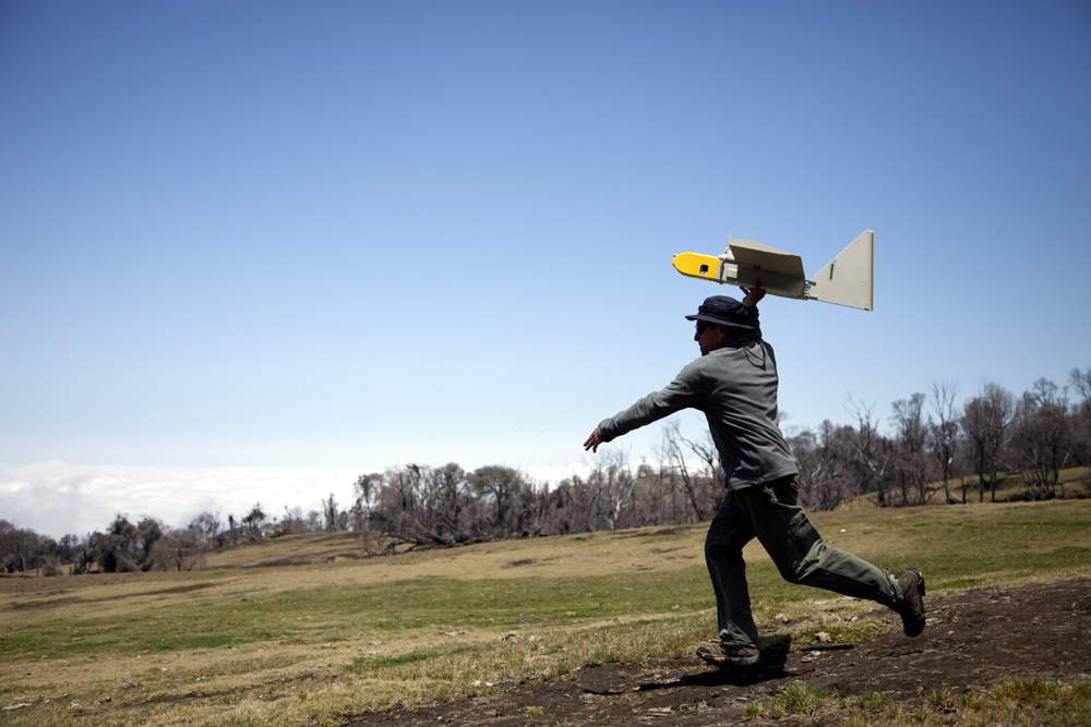
Research scientists at NASA’s Ames Research Center, Moffett Field, Calif., negotiated the transfer of three Aerovironment RQ-14 Dragon Eye UAVs from the United States Marine Corps (USMC) via the General Services Administration’s San Francisco office. These small electric unmanned aircraft weigh 5.9 pounds, have a 3.75-foot wingspan and twin electric engines, and can carry a one-pound instrument payload for up to an hour within a volcanic plume (Credits: NASA/Randy Berthold).
NASA Earth science researchers last month traveled to Turrialba Volcano, near San Jose, Costa Rica, to fly a Dragon Eye unmanned aerial vehicle (UAV) — a small electric aircraft equipped with cameras and sensors — into the volcano’s sulfur dioxide plume and over its summit crater, to study Turrialba’s chemical environment. The project is designed to improve the remote-sensing capability of satellites and computer models of volcanic activity.
The study, called “In Situ Validation and Calibration of Remotely Sensed Volcanic Emission Data and Models,” launched 10 flights between March 11-14, 2013, into the volcanic plume and along the rim of the Turrialba summit crater approximately 10,500 feet above sea level (ASL). The launch site was located at 8,900 feet ASL, and flights ranged up to 12,500 feet ASL, more than 2,000 feet above the Turrialba summit. Project objectives included improving satellite data research products, such as maps of concentration and distribution of volcanic gases, and transport-pathway models of volcanic plumes.
Ames research scientist Rick Kolyer launches Dragon Eye UAV. (Credits: NASA/ Randy Berthold)
“It is very difficult to gather data from within volcanic eruption columns and plumes because updraft wind speeds are very high and high ash concentrations can quickly destroy aircraft engines,” said David Pieri, the project’s principal investigator and a research scientist at NASA’s Jet Propulsion Laboratory (JPL), Pasadena, Calif. “Such flight environments can be very dangerous to manned aircraft. Volcanic eruption plumes may stretch for miles from a summit vent, and detached ash clouds can drift hundreds to thousands of miles from an eruption site.
To penetrate such dangerous airspace, UAVs, especially those with electric engines that ingest little contaminated air, are an emerging and effective way to gather crucial data about ash and gas concentrations and their lateral and vertical distribution.
To accomplish project objectives, research scientists at NASA’s Ames Research Center, Moffett Field, Calif., used three Aerovironment RQ-14 Dragon Eye UAVs which were acquired from the United States Marine Corps (USMC) via the General Services Administration’s San Francisco office. These small electric unmanned aircraft weigh 5.9 pounds, have a 3.75-foot wingspan and twin electric engines, and can carry a one-pound instrument payload for up to an hour within a volcanic plume.
“This project is great example of how unmanned aircraft can be used for beneficial civilian purposes – in this case for better understanding Earth system processes and the impact of volcanism on our atmosphere,” said Matthew Fladeland, airborne science manager at Ames. “By taking these retired military tools, we can very efficiently and effectively collect measurements that improve NASA satellite data and aviation safety.”

The study launched 10 flights between March 11-14, 2013, into the volcanic plume and along the rim of the Turrialba summit crater approx. 10,500 feet above sea level (Credits: Google).
Ames team members integrated payload instruments onto the UAV, which included the standard USMC visible and infrared video cameras, sulfur dioxide and particle sensors, and automatic atmospheric sampling bottles keyed to measure sulfur dioxide concentration. Researchers also operated the UAV, directing it into a volcanic plume to characterize its chemical and physical environment. This capability was especially important during simultaneous flights by NASA’s Terra spacecraft with the ASTER imaging radiometer. Next year, as part of this project, Ames also will operate the larger SIERRA unmanned aircraft (about 400 pounds takeoff weight, 100-pound payload), which will carry a more sophisticated mass spectrometer to measure additional gases in the Turrialba volcano plume.
For more information about NASA’s HyspIRI Mission Study, visit: http://hyspiri.jpl.nasa.gov/
For more information about NASA, visit: http://www.nasa.gov/


![A trajectory analysis that used a computational fluid dynamics approach to determine the likely position and velocity histories of the foam (Credits: NASA Ref [1] p61).](http://www.spacesafetymagazine.com/wp-content/uploads/2014/05/fluid-dynamics-trajectory-analysis-50x50.jpg)


Leave a Reply